Liste de favoris
La liste de favoris est vide.
Le panier est vide.
Envoi gratuit possible
Veuillez patienter - l'impression de la page est en cours de préparation.
La boîte de dialogue d'impression s'ouvre dès que la page a été entièrement chargée.
Si l'aperçu avant impression est incomplet, veuillez le fermer et sélectionner "Imprimer à nouveau".

Olten. 1:50'000

Hauenstein - Wigger-, Suhren und Wynental. Wanderkarte
CartesCarte (cartes géographiques, plans de la ville)
Classement des ventes 90dansCartes
CHF22.50

Description

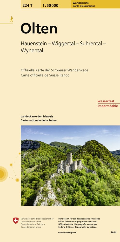
The new hiking maps make route planning easy with useful additional information such as public transport stops, points of interest, observation towers, secluded inns or car parks. Switzerland mobility's hiking routes are also marked. Each map also contains five attractive hiking suggestions by the Swiss hiking Federation.The maps are even easier to read thanks to the new national map graphics. Their fresh and modern appearance as well as hiking trail categories in colour and pictograms help hikers find their way quickly and safely.The trail categories "hiking trail", "mountain hiking trail" and "alpine hiking trail" are immediately recognizable by the symbol colours yellow, red and blue. hard-surfaced and unsurfaced trails are also easy to identify.The new hiking map contains Switzerland's entire netword of hiking trails printed on waterproof, tear-resistant paper. All information is clearly arranged on one page.

Détails

ISBN/GTIN978-3-302-30224-9
Type de produitCartes
ReliureCarte (cartes géographiques, plans de la ville)
Date de parution01.01.1998
No. de série224/T
LangueAllemand
DimensionsLargeur 108 mm, Hauteur 217 mm, Épaisseur 10 mm
Poids58 g
Groupe de produitsSuisse
CatégorieCartes
Plus de détails

Série

Evaluations

Mot-clé

Recommandations

Les clients ayant acheté cet article ont aussi acheté

Recherches récentes